Project: Effects of post-fire management on vegetation and fuels following successive wildfires
Funding Provided by:
Collaborating Organizations:


Project Abstract: Increasing incidence of large wildfires with extensive high severity effects across the western U.S. has shifted the attention of land managers towards post-fire landscapes. Restoration of specific resources damaged by wildfire has traditionally been the focus of management efforts; however there is growing recognition that larger scale post-fire management may be needed to promote resilience to future reburns, increase biodiversity, and reestablish pre-fire vegetation types, such as montane mixed conifer forests. Previous work conducted by many of the same investigators on this proposed study demonstrated that high severity fire effects in an initial fire can create conditions, such as standing snags and dense shrub vegetation that promote high severity fire effects in subsequent reburns. This potential feedback trajectory with subsequent fires (i.e. one in which extensive stand-replacing fire will promote more stand-replacing fire) has the potential for long-term state change from forest to persistent shrubland or grassland. In our previous work, we hypothesized that post-fire management had the potential to alter vegetation and fuels trajectories, and shift the fire regime back towards low to moderate severity fires that promote landscape-scale forest heterogeneity and structural diversity. In our proposed study we intend to test this hypothesis to determine if post-fire management activities (e.g. tree planting, thinning, salvage logging, and fuel reduction) can significantly affect fire severity and influence plot and landscape-scale vegetation patterns and fuel loadings after subsequent reburns. Our study area is located in the northern Sierra Nevada of California on the Plumas and Lassen National Forests. We propose to resample an extensive set of field plots that were established after the 2000 Storrie and 2008 Rich fires and were subsequently reburned by the 2012 Chips Fire. We will also incorporate LiDAR (Light Detection and Ranging) derived vegetation and fuels information to expand our analysis to the landscape scale. Our intent is to provide fire and fuels managers with critical information about how to manage post-fire landscapes before undesirable, long-term vegetation and fuels trajectories have been established as a result of successive, high severity fires.

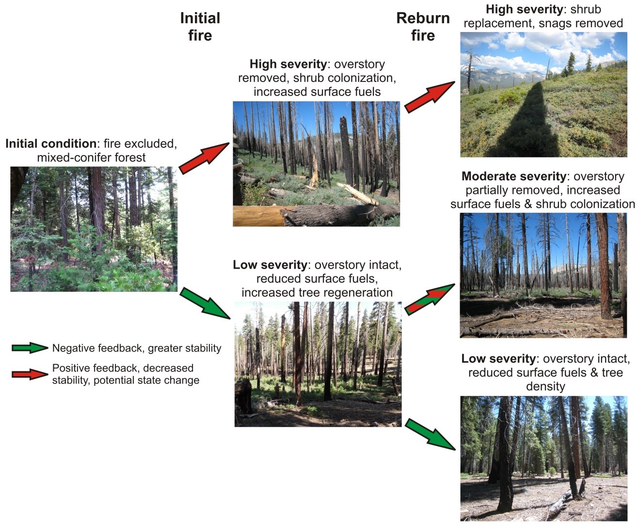
Figure 1: Our conceptual model of potential pathways for post-fire vegetation and fuel dynamics following initial fires and reburns. Time between initial fire and reburn is assumed to be relatively short (5-15 years). Pathways are coded for the type of ecological feedback based on expected change to the dominant vegetation in response to different fire severity levels and effects these vegetation changes would have on subsequent fires.

