Projects
1) Peatlands Geophysics
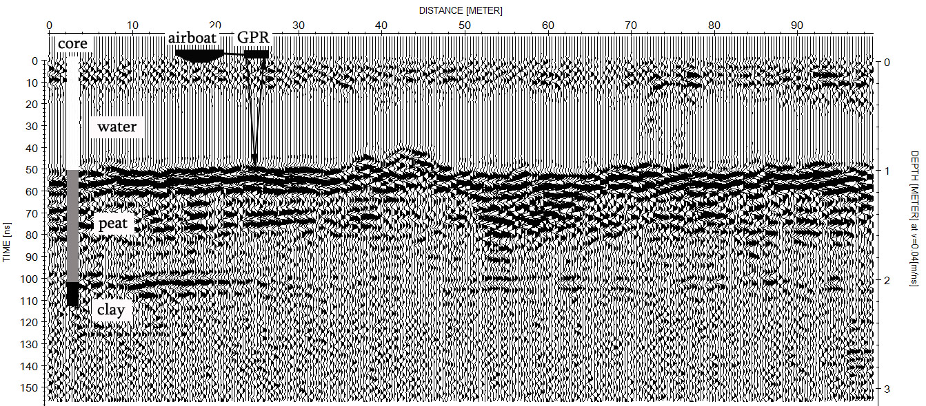
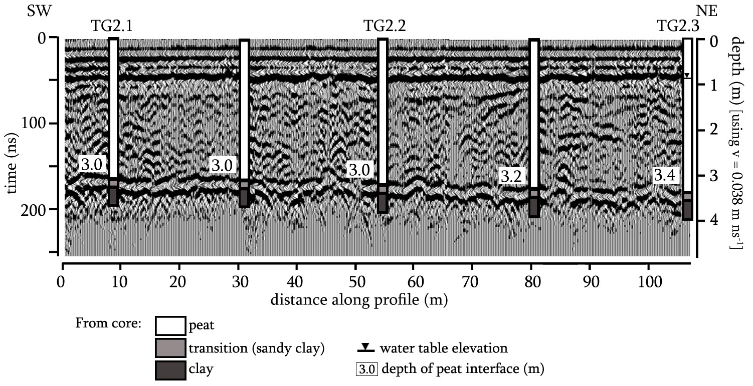
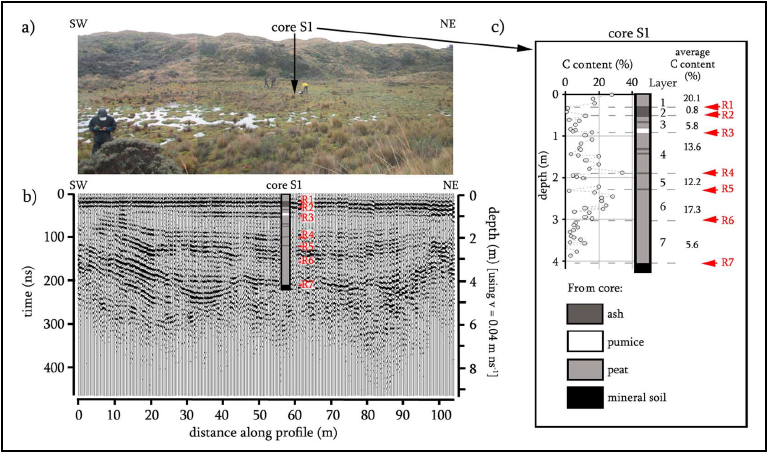
1a) Field Scale: current projects include both discrete and time-lapse measurements using electromagnetic (EM) methods such as ground-penetrating radar (GPR) and terrain conductivity. Discrete measurements are focused on estimating carbon stocks at high spatial resolution. For example, Figure 1, Figure 2, and Figure 3 show examples of GPR common offset transects in the Everglades (FL), West Kalimantan (Indonesia); and the Ecuadorian Andes (Ecuador). The images allow determining the thickness variability of the peat column with a lateral resolution of 15-20 cm (confirmed with direct sampling). Such an approach would be unfeasible using traditional methods such as direct coring. Similar datasets have been collected in a wide variety of boreal and tropical peatland systems worldwide, including Maine, Minnesota, Oregon and Florida in the US, or in several international locations such as Indonesia, Ecuador, Spain, and the UK.
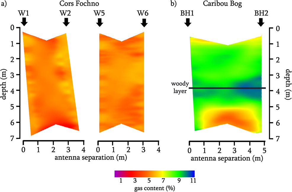
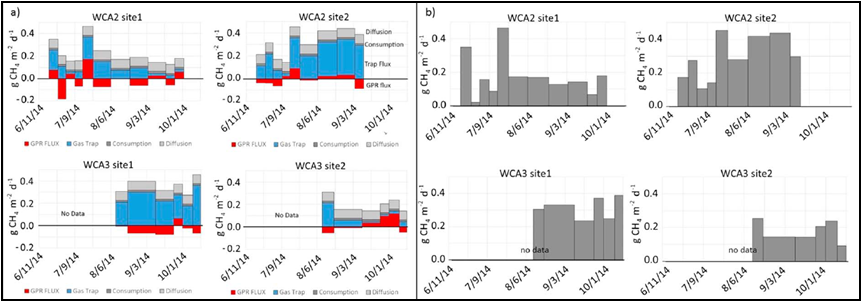
Time-lapse and discrete measurements at the field scale are also focused on better understanding the spatial and temporal variability of biogenic gas release and production (mainly methane and carbon dioxide) in peat soils. Figure 4 shows two sets of tomographic images from borehole GPR surveys collected in two peatlands: a) Cors Fochno (UK) and b) Caribou Bog (Maine). The images show the estimated distribution of gas content within the peat column and reveal marked differences related to how gas accumulates in different peatland systems (see Comas et al, 2013 for further details on this specific survey). Figure 5 shows a time-lapse dataset collected at several sites in the Everglades depicting the variability in GPR estimated gas content, flux release, and inferred gas production within the peat column over a 4 month period. Other methods such as gas traps, time-lapse cameras, and surface deformation sensors were also used. The dataset depicts rates of flux release inferred from GPR and gas traps expressed in g CH4 m2 day-1. Further details about this dataset can be found in Wright and Comas, 2015. Surveying sites for monitoring temporal changes in gas dynamics have been deployed in several locations in Maine and in Florida, mainly in the Everglades with active sites in WCA-1, WCA-2, and WCA-3 being monitored.
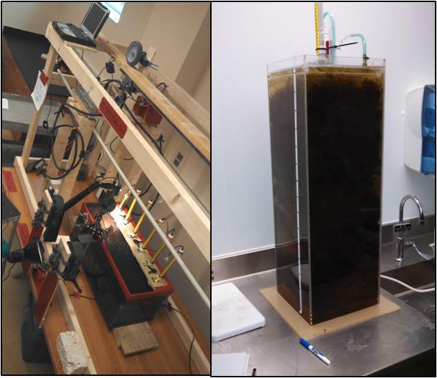
1b) Laboratory Scale: similar time-lapse measurements using EM methods for investigating the temporal and spatial variability in gas dynamics and rapid gas releasing events (i.e. ebullition) as described above are also being monitored in the laboratory. The lab currently holds peat monoliths (Figure 5) from several loc ations including Maine, Minnesota, Oregon and Florida, and intends to expands to peat samples from other locations around the world including Indonesia, Ecuador and Spain. Several lines of research are intended for the near future: 1) to establish a comparison of gas dynamics from peat soils from a wide variety of latitudes (from boreal to tropical) treated under the same conditions; 2) to induce changes in temperature (by using temperature controlled environmental chambers) and explore how warmer temperatures may alter current gas dynamics (i.e. climate change scenario); 3) to better constrain temporal releases by collecting continuous GPR measurements using an autonomous rail system (Figure 5); and 4) to better constrain spatial distribution of gases and upward migration by measuring gas distribution along a 1m long monolith from the Everglades representing the entire peat column under field conditions (from surface to mineral soil contact) (Figure 5).
2) Karst Geophysics
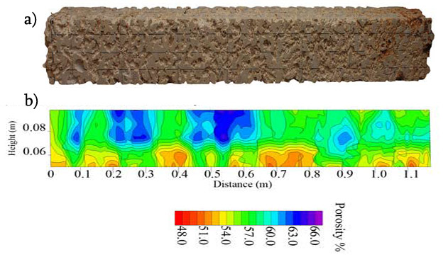
Both laboratory and field-based studies that explore the use of hydrogeophysical methods in karst environments are also currently undergoing in the Environmental Geophysics Lab. Field-based studies include the imaging of dissolution features and certain karst environments such as tufa mounds. Figure 6 shows a survey collected in Basturs (Spain) using a 50 MHz RTA antenna over a tufa mound and depicts depths of penetration up to 30 meters. Figure 7 exemplifies some laboratory work to estimate porosity from Miami limestone samples. See Mount and Comas, 2014 for further information
3) Critical Zone Geophysics
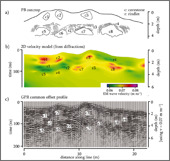
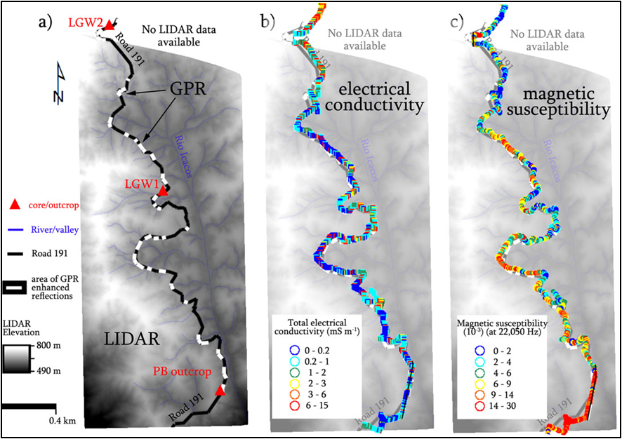
Current projects include work at the Luquillo Critical Zone Observatory (CZO), using a variety of methods (GPR, electrical resistivity imaging, terrain conducutivity, magnetics, or shallow seismics) to investigate weathering processes at different scales of measurement, from outcrop (Figure 8), to landscape scales (Figure 9).
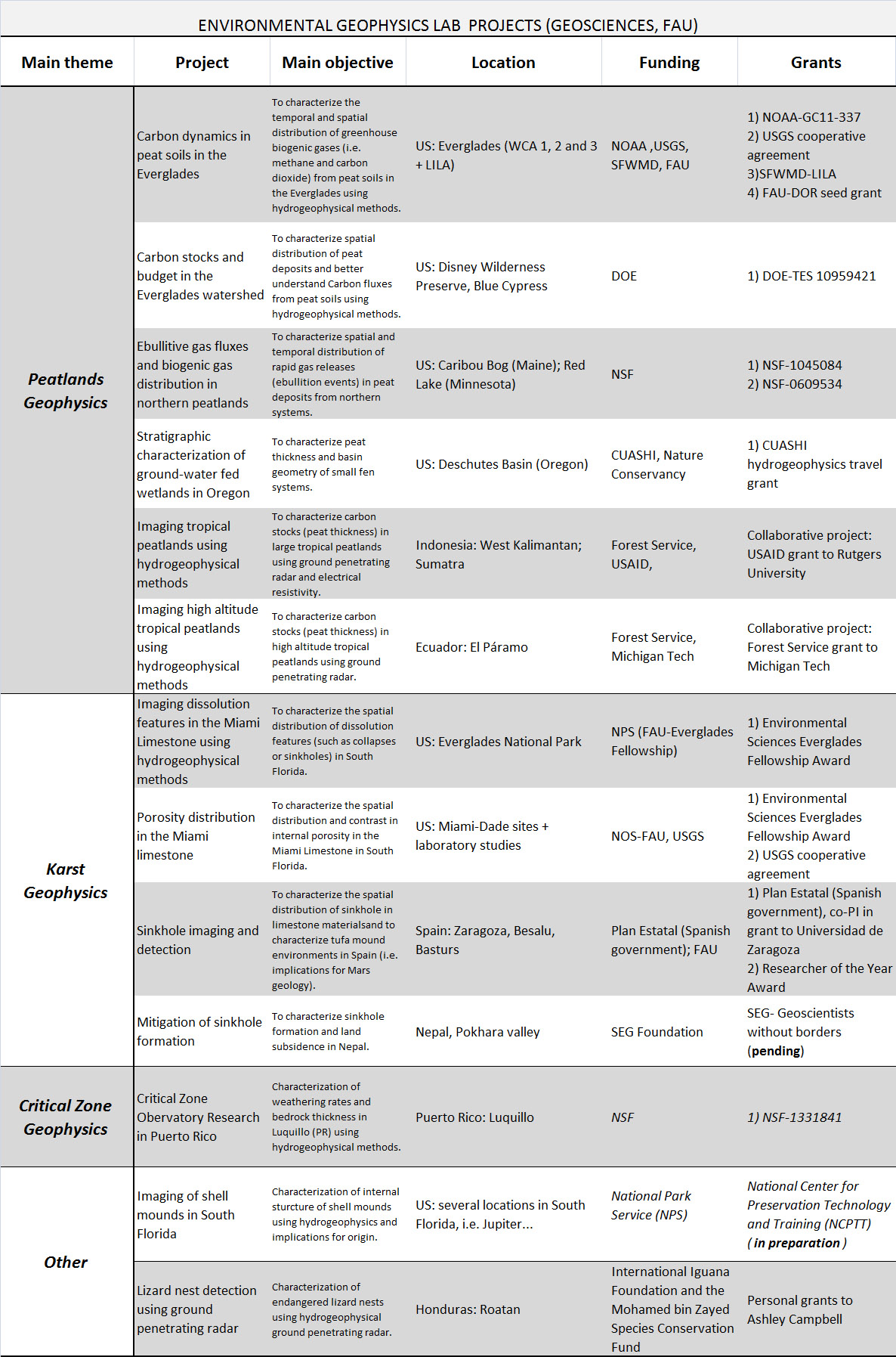
Table 1: summary of current ongoing projects in the Environmental Geophysics Lab
|


